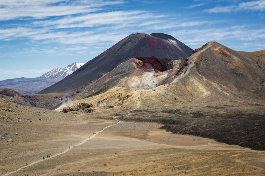
The Tongariro Alpine Crossing is considered one of the finest one-day hikes in the world. The Tongariro Crossing is a 19.4 km long journey located in the center of New Zealand’s North Island, taking you through a dramatic volcanic landscape. It features steaming vents, ancient lava flows, colorful lakes and breathtaking views. Whether you are an experienced hiker or embarking on this exciting journey for the first time, this guide will provide you with all the information you need to successfully complete the Tongariro Alpine Crossing.
For those planning this trip, it is mandatory to arrange for the Alpine Crossing shuttle as this track is one-way. The Tongariro Crossing hike begins at the Mangatepopo Car Park and finishes at the Ketetahi Car Park on the other side. Hikers must plan their transport accordingly to ensure a smooth experience when they finish the Tongariro Alpine Crossing trail Ketetahi side.
Overview of the Tongariro Alpine Crossing
Distance: 19.4 km (12 mi)
Duration: 6-8 hours
Difficulty level: moderate to challenging
Highest elevation: 1,886 meters (6,188 ft) at Red Crater
Best time: November to April (New Zealand’s summer months)
Starting point: Mangatepopo car park
End point: Ketetahi Car Park
Preparing for the Hike
1. Check the Weather Conditions
Weather in Tongariro National Park can be unpredictable. Sudden changes in temperature, strong winds and snowfall can occur even in summer. Check the weather from the MetService website or local visitor center before you go on a hike.
2. What to Pack
Required Gear:
- Hiking Boots: Sturdy, waterproof boots with good ankle support.
- Clothing: Layered clothing (base layer, insulating layer, waterproof jacket, and windproof pants).
- Backpack: A small daypack with adjustable straps.
- Food and Water: At least 2-3 liters of water, energy bars, nuts, sandwiches.
- Sun Protection: Sunglasses, hat, and sunscreen (UV levels are high in New Zealand).
- Emergency Supplies: First aid kit, flashlight, whistle, and extra batteries.
3. Transportation and Parking
Since the crossing is a one-way hike, you will need to arrange transport. Shuttle services operate from nearby towns such as Turangi, and National Park Village. If you are driving, you can park at the Ketetahi Car Park and take a shuttle to the starting point at Mangatepopo Car Park.
The Hike: Section by Section
1. Mangatepopo to Soda Springs (1-1.5 hours)
The journey starts from the Mangatepopo car park, where you climb gently through open valleys and lava fields. The trail is well maintained and easy to follow. After about an hour, you will reach Soda Springs, where there is a small waterfall. Take some rest here, as the next step will be challenging.
2. Soda Springs to South Crater (1 hour)
Next comes the Devil’s Staircase, which is a steep which is very difficult to climb. This is the real test of your fitness. The height increases faster in this section, but you can get amazing views of Mount Ngauruhoe .
Read More: Top 10 tourist attractions in Singapore
3. South Crater to Red Crater (1-1.5 hours)
Via South Crater you head towards Red Crater, the highest point of this hike. The climb is steep and exposed, with loose volcanic stone. Once you reach the top, you will be treated to panoramic views of the red and black awe-inspiring Red Crater and Emerald Lakes.
4. Red Crater to Emerald Lakes (30 minutes)
From here you have to descend a steep and slippery slope. Emerald Lakes, sparkling lakes rich in minerals, display an otherworldly beauty. It is an ideal place for lunch.
5. Emerald Lakes to Blue Lake (20 minutes)
After this, you reach the Blue Lake, the largest lake in the region. It is considered sacred in Maori culture, so swimming in it or touching it is prohibited.
6. Blue Lake to Ketetahi Shelter (1-1.5 hours)
This section takes you down through an active volcanic field, where you can see steaming vents and hot water sources. After resting here at Ketetahi Shelter, prepare for the final leg.
7. Ketetahi Shelter to Ketetahi Car Park (1.5-2 hours)
The final section is a long, gently sloping trail through alpine meadows and dense forest. This section is easier than the earlier steep climbs, but can be tiring. Finally, this unforgettable journey comes to an end by reaching the Ketetahi car park.
Safety Tips
Start early: Start before 8:00 AM so you can complete the journey in ample light.
Don’t stray from the path: The path is difficult, so stick to the marked footpath.
Be prepared for weather changes: always have warm and waterproof clothes.
Know your limits: If you feel unwell or under the weather, turn back.
Conclusion
The Tongariro Alpine Crossing is an amazing hiking experience, combining volcanic landscapes, stunning views and natural beauty. If you go with the right preparation and proper planning, it will be a memorable trip.
So, are you ready to explore the Tongariro Alpine Crossing? Lace up your shoes, pack your bags, and set out on this memorable adventure!